
Map Kibera
Nairobi presents the largest slum settlement in Africa, and one of the biggest slum populations in the world. In 200 settlements, homogenously named Kibera, there are approximately 2.5 million people. The people of Kibera inhabit 6 % of the land but consist of 60 % of Nairobi’s population (Kibera Facts & Information,2018).
| Figure 1 Geomapping by the MapKibera team Note: Community mappers team collecting data, using GPS and computers to analyse and edit the information. Conducting surveys, they map the slum’s main features to connect and strengthen the community identity.From “Geomapping by the MapKibera team”, by Team Ushahidi, 2013 (https://www.flickr.com/photos/ushahidi/8526959049/in/photolist-dZuTRk). Copyright 2013 by Team Ushahidi | Figure 2 Kibera After Mapping Note: With great details, clinics, pathways and markets has been pointed out.The map illustrates health and education centres and, visualise the main information for the community access. From “Kibera After Mapping”, by M. Maron, 2010 (https://www.flickr.com/photos/mikel_maron/4529952015/in/photolist-7UibUX-bftkyX-bftjMR-bftj4t-bftiNZ-bftkZt-bftgcr-bftgRR-bftgAP-bfthyc-bftidx-bftgrx). |
Utilising Paul Polak’s concept, “Update the old package with cutting-edge materials” (Polak, 2007, p.24) in the attempt to divert the chronical social-economical state, Map Kibera was formed to connect marginalised communities through an affordable and serviceable, open digital map (Map Kibera, n.d.). This empowers the build of a resilient community through the gathering of public information, such as water points, clinics and markets (Map Kibera, n.d.). To strengthen the community identity, Map Kibera’s tangible benefits goes past the scope of mapping and has created a community-driven platform (Taka, 2018). Map Kibera has made this once invisible community, observable to the world.
Kibera’s digital community provides its residents a voice on current events and issues in their local community (Tavaana, 2019). Through photos, videos and citizen journalism, the community reports and documents on critical issues, such as education, health and safety, therefore encouraging an active community engagement (Tavaana, 2019). This project is empowering a marginalised community to actively self-advocate, encouraging a sense of ownership to their social-economic challenges.
Map Kibera is not a standalone, being used for other worldwide initiatives. In 2010 the initiative was introduced to another Nairobi slum, as “Map Kibera Goes to Mathare,” (KiberaNewsNetwork, 2011). After Haiti’s 2010 earthquake, a crises map was modelled after Map Kibera, mapping remaining serviceable roads and infrastructure. However, the project remained for Haitians to continually map their health, education, sanitation and water facilities (Hesse, 2010). These examples show how technology, using a crowd-based approach, is efficient in the area of international development. It has also engaged the local youth, who now network with Nairobi’s technology community, building skills to advance prospects for employment (Tavaana, 2019).
Figure 3
Wall Painting in Kibera
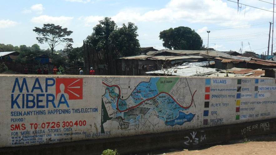
Note: Abeautiful wall painting showing the level of community engagement and, flow-on effect that led to label and monitor the elections.An effective example of the community use of technology (SMS) to share and connect the Kiberans voices.From “Wall Painting in Kibera”, by mapKibera, 2013 (https://www.flickr.com/photos/mapkibera/8637668001/).
Map Kibera continues, with tangible benefits for mapping facilities and infrastructure, that impact lives of Kibera’s population. In 2013 during the Kenyan election, Map Kibera’s flow-on effect led to the labelling and monitoring of polling stations (Tavaana, 2019). It continues to utilise Polk’s concept (2007) of ‘Update the old package’ (p.24), as a warning platform for natural disasters, and to raise an understanding of local needs (Tavaana, 2019).
Sustaining the outcome of this initiative will ensure a continued expandability of the project.
Kibera will remain visible to the world.
Reference List:
Kibera UK. (2018). Kibera Facts & Information. Retrieved July 27, 2022, from https://www.kibera.org.uk/facts-info/#:~:text=There%20are%20approximatly%202.5%20million,the%20biggest%20in%20the%20world.&text=The%20Government%20owns%20all%20the%20land
Polak, P. (2007). Design for the other ninety percent. In C. Smith (ED.), Design for the other 90% (pp. 19–25). New York: Cooper-Hewitt, National Design Museum, Smithsonian Organisation. Retrieved from: https://librarysearch.swinburne.edu.au/permalink/f/12p6ajs/SUT-EQUELLA-
SUBJECT-MATERIALSf9472fc2-4ad5-45e9-bc92-64c3ad033eb7/1
Map Kibera. (n.d.). Map Kibera. Retrieved July 27, 2022, from https://www.mapkibera.org/work/locations/
Taka. (2018, March 25). Map Kibera: Empowering Africa’s Biggest Slum with Collective Wisdom. Digital Innovation and Transformation. Retrieved July 27, 2022, from https://digital.hbs.edu/platform-digit/submission/map-kibera-empowering-africas-biggest-slum-with-collective-wisdom/#_ftnref10
Tavaana. (2019). Empowering Nairobi’s slums: The Map Kibera Project. Retrieved July 27, 2022, from https://tavaana.org/en/en/content/empowering-nairobis-slums-map-kibera-project
KiberaNewsNetwork. (2011, Jan 28). Map Kibera goes to Mathare [Video]. YouTube. Retrieved July 27, 2022, from https://www.youtube.com/watch?v=jaKTKBioZ88
Hesse, M. (2010, January 16). Crisis mapping brings online tool to Haitian disaster relief effort. Washington Post. Retrieved July 27, 2022, from https://www.washingtonpost.com/wp-dyn/content/article/2010/01/15/AR2010011502650.html
Team Ushahidi. (2013). Geomapping by the MapKibera team. Flickr. https://www.flickr.com/photos/ushahidi/8526959049/in/photolist-dZuTRk
Maron, M. (2010). Kibera After Mapping. Flickr. https://www.flickr.com/photos/mikel_maron/4529952015/in/photolist-7UibUX-bftkyX-bftjMR-bftj4t-bftiNZ-bftkZt-bftgcr-bftgRR-bftgAP-bfthyc-bftidx-bftgrx
mapKibera. (2013). Wall Painting in Kibera. Flickr. https://www.flickr.com/photos/mapkibera/8637668001/